Helpful Information around Flooding
📞 Phone numbers
For emergency help in floods and storms, call the NSW State Emergency Service on 132 500.
🚑 In life-threatening situations call triple zero (000) immediately.
🗺 Maps
Preludes to flooding of Moree
Aerial Map of the 2012 Moree township in flooding
Useful websites
🚧 Traffic/Road closures
MyRoads info
Live Traffic
🌧 River heights/forecasts
For more emergency information, advice, and access to the latest river heights and rainfall observations and forecasts.
* NSW SES website
* NSW SES Facebook
* Latest River Heights and Rainfall Observations
* Latest NSW Warnings
* Rainfall Forecasts
* Elders Local Weather Forecast
🌧 Queensland
* Queensland BOM
* Balonne Shire Council
* Goondiwindi Region
📻 Radio Facebook Pages
Outback Radio 2WEB
ABC New England North West
NOW FM
✅ Emergency news is broadcast on ABC Local Radio
🐴 Animals
For rural animal and livestock assistance, contact your Local Land Services Office
Follow all signage in place, drive to conditions and remember, if it's flooded FORGET IT!
River Heights

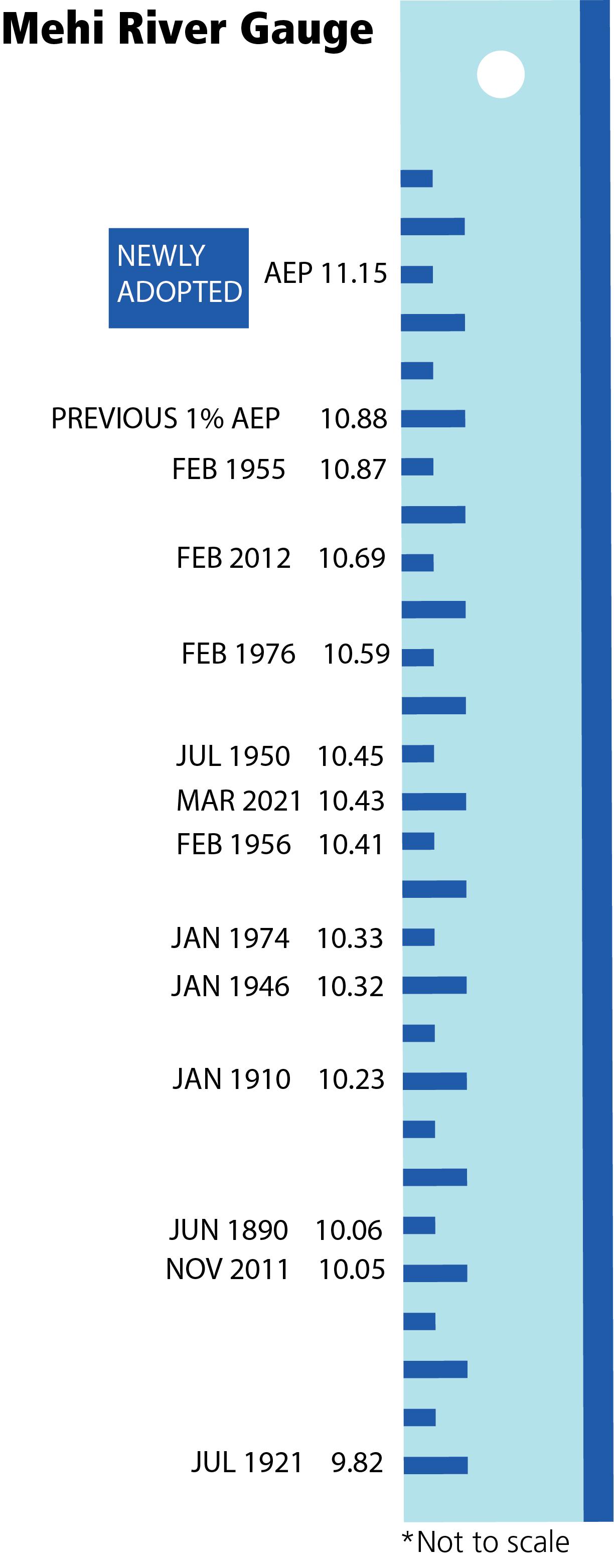
Moree - Key River Heights for Mehi River
<< Please see diagram
Boggabilla - Key River Heights for Macintyre
Minor 5 metres
Moderate 11.5 metres
Major 12 metres
6.4m Causeway at Boonal Bridge closed. Residents living west of the Levee have no access to Boggabilla.
7.3m Water begins flowing into Whalan Creek. Bruxner Highway is cut at the Whalan Creek Causeway. Toomelah is isolated.
10.54m Access becomes difficult along some roads and water crosses the Newell Highway, 20km south of Boggabilla.
11.4m Water enters Brown Street, Boggabilla and areas beyond the Tafe College. Flood water threatens Boggabilla township and Elambe Caravan Park.
11.76m Flood water breaks the banks of the Macintyre River at “River Common” and runs over Riverview Road, Boggabilla and towards Elambe Caravan Park. Evacuation begins
Mungindi - Key River Heights for Barwon River
Minor 6.10 metres
Moderate 6.70 metres
Major 7.20 metres
Mungindi in Flood
