


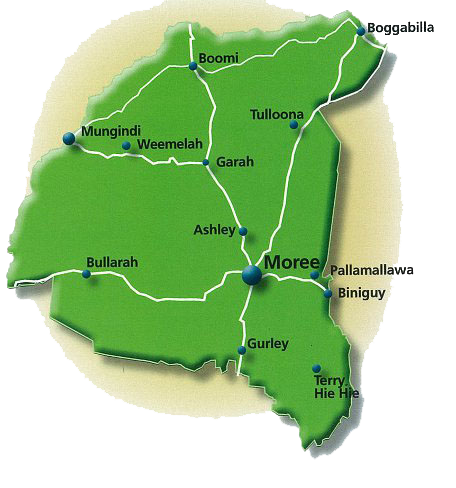
Towns and Villages
Moree is the Shire’s largest centre and surrounded by the villages Ashley, Biniguy, Boggabilla, Boomi, Bullarah, Garah, Gurley, Mungindi, Pallamallawa, Terry Hie Hie and Weemelah. Aboriginal communities managed by Local Aboriginal Land Councils are located at Toomelah, near Boggabilla, and at Mehi Crescent and Stanley Village in Moree.
Ashley
Ashley, formally known as Bogree, is a small rural village along the Carnarvon Highway, 17 km north of Moree. It offers rural living, under cover play area for the kids, hall, a park and a small Rural Fire Service. It is centre of the cotton producing centre with two of Australia’s largest cotton gins operating in the district.
Biniguy
Welcome to Biniguy, where the pecan nut is king! The Trawalla Pecan Farm was established in 1965. It is operated by Stahmann Farms and is the largest pecan farm in the Southern Hemisphere, located on the banks of the Gwydir River, a few kilometres to the west of Biniguy.
The main employment industry in Biniguy is agriculture. There is a silo site operated by GrainCorp for the receiving and storage of grain located in the village. The community of Biniguy is 40km east of Moree.
Boggabilla and Toomelah
Home of the famous Wobbly Boot Hotel (made famous by country singer Stan Coster), Boggabilla is located on the Newell Highway, 115km north of Moree and just south of the Queensland border with Goondiwindi just 8.5km away.
The village contains a school, TAFE, post office, pub, butcher, general store, Town and Country Club, a few small businesses and a service station. There is memorial to Australia’s first Aboriginal fighter pilot Leonard Victor Waters ‘Black Waters’ in the grounds of the park.
Toomelah
The Indigenous community of Toomelah (formerly Toomelah Aboriginal Mission), home to 300 Kamilaroi people and with its own school and co-op, is 14km away from Boggabilla. West of the town is Boobera Lagoon which has been a popular swimming, picnicking, sailing, boating and waterskiing spot. It is considered a site of great significance by the area's indigenous inhabitants.
Boomi
On the NSW side of the MacIntyre River, 94 km north of Moree is the town of Boomi.
The town’s biggest asset is the hot Artesian Spa Baths, Boomi Community Co-op (a not for profit co-operative with 110 members) and the Boomi BATS. The community welcomes overnight visitors to enjoy their small community with all it has to offer from self-guided tours, fishing, taking a cotton tour and theatre productions.
Every two years, the community of Boomi swells as people from all around come to watch the Boomi BATS performance.
Bullarah
The tiny village of Bullarah is 70 km west of Moree on the Gwydir Highway. The once plain façade of the community hall built in the mid 1930s was transformed by Lightning Ridge artist John Murray with assistance from Bob Barret to a quirky rural mural.
Garah
Garah is 51km north west of Moree. The Mungindi (North West) railway line passes through the village and although the station is closed (open between 1913 – 1974) it is used for celebratory community events. Facilities in the town include a post office, primary school, police station, tennis courts, grain silo, CWA hall, community hall, pre-school, corner shop, pub, racecourse, small petrol bowser, Catholic church and a Presbyterian Church.
One of Australia's oldest picnic race meetings are held at Garah. The Talmoi Picnic Races, part of the Golden Triangle Bush Races are held in June each year.
Gurley
Gurley is 32km south of Moree on the Newell Highway. The grain silos are an unmistakable sight as you pass through the village. Take a break, and in true country style, receive a warm welcome at the Gurley Hotel. The pub once had a second storey but it was blown away in a storm many years ago.
Mallawa
The community of Mallawa, 60km west of Moree, stages the Mallawa Picnic Races, part of the Golden Triangle Bush Races in June each year.
The Mallawa Racetrack, opened in 1930, boasts a unique horseshoe-shaped track with a long 400m home stretch that keeps punters on the edge of their seats. Whenever the Mallawa Picnic Races are called off because of rain, the racegoers head to the nearby Mallawa Hall to let their hair down.
Moree
Moree is a progressive and pretty town on the banks of the Gwydir and Mehi Rivers. At the junction of the Gwydir and Newell Highways, with regular air and rail services to Sydney 608km southeast, and Brisbane 473km to the northeast.
Moree is well placed to serve as a major regional centre in an important farming and grazing area. With a population of 9,346, Moree is small enough to offer residents and visitors a relaxed lifestyle, and large enough to provide them with most of the goods and services they require. The town offers access to all the major banks, two large supermarkets, newsagencies, homewares stores, furniture and electrical stores, hardware and produce stores, a well-equipped hospital, an aged care facility, chemists, doctors, dentists, schools and childcare facilities, real estate and stock and station agencies, boutiques, a bookshop, a library and an art gallery, plenty of coffee shops, a nursery, a regional airport, hotels and motels, Rural Fire Service and State Emergency Services branches, lovely parks, excellent ovals, gyms and tennis courts, a fabulous golf course, an RSL Club and only two sets of traffic lights.
Moree’s most famous attraction, however, is the Moree Artesian Aquatic Centre (MAAC), formerly known as the Moree Hot Artesian Pool Complex. The MAAC underwent a major redevelopment that will ensure it continues to entice patrons from far and wide for some time to come.
Mungindi
Mungindi's uniqueness is a town which straddles the Barwon River, with either side of the river marking the border between Queensland and New South Wales.
Mungindi is 120km from Moree and offers visitors a great stop over if continuing on the Carnarvon Highway. The Central Business District is located in NSW, but uniquely there are two Police stations, one in each state. The schools are in NSW, with the Hospital is situated on the Queensland side. The Rural Transaction Centre on the NSW side and incorporates many local services and businesses under one roof including the Mungindi branch of the Big Sky Libraries.
In Summer be aware that this quirky town runs on two time zones due to eastern daylight savings time adopted in NSW but not Queensland!
The township offers hotel accommodation at the Jolly Swagman Hotel, along with a Caravan Park. While you are there you can enjoy a spot of fishing in the Barwon River or relax in the artesian waters at the local municipal pools.
Just over the Queensland border you can turn off to see the famous ‘One Ton Post’. The One Ton Post, believed to be the largest survey peg in Australia, was erected by John Cameron in 1881. It marks the completion of two years of surveying the 29th parallel, forming the border between NSW and QLD. The One Ton Post stands where the 29th parallel meets the Barwon River. If you like looking at historical sites, enjoy viewing the displays at the local Historical Park.
Pallamallawa
Affectional known as "Pally" the small rural village is 30 kilometres east of Moree on the banks of the Gwydir River, just two kilometres off the Gwydir Highway.
The village is a service centre for surrounding agricultural production which includes irrigated crops (such as cotton and pecans), as well as livestock (mostly beef cattle) and cropping (mostly cereals and rotational legumes). The pecan industry is now well established but growth in other novel crops, including olives, demonstrates a high level of innovation in agriculture.
Pallamallawa has a number of food and grocery service businesses, including a post office with banking facilities, a primary school, sporting amenities, a café/takeaway shop and a pub.
Terry Hie Hie
The tight knit community of Terry Hie Hie is located 47km southeast of Moree on the Tycannah Creek. Traditional Kamilaroi Aboriginal people once used the lands around Terry Hie Hie for ceremonial events. There are six significant cultural reserves, with places to picnic, opportunities for birdwatching, and a beautiful walking track.
Terry Hie Hie Aboriginal area forms a tangible link between the Kamilaroi ancestors and their living descendants.